Backroads Back Home
In which M2 takes a California road least traveled
 Coming home from a wild warehouse party in the badlands of San Francisco on Sunday morning (more on that later, when I get the pictures), I stopped at Harris Ranch to buy some fresh Harris Ranch beef to bring to some friends at in the south. I bought some pre-cooked BBQ ribs, a Bobby Darren CD and a map – I had forgotten to bring one on the way up.
Looking at the map I noticed a thin red line running southward that vaguely paralleled the I-5, but to the west, called Highway 33. There was little on the map to indicate any points of interest, but I was curious and decided to take a chance. It turned out to be a chance well taken.
I took State Highway 198 East to toward Coalinga, a little town noted only for a famous kidnapping of an entire school bus full of children in the 1970s, when I was a boy. Where 198 met 33, I noticed a historical marker. I pulled over to investigate and was pleased – no, thrilled – to see that it marked the place where Joaquin Murietta, the notorious bandit of early California and the precursor of Zorro, was finally killed and beheaded. Actually the marker, California State Marker # 344 doesn’t mark the exact spot of the killing, but points rather to it – about 15 miles up a dirt road that winds around Black Mountain peak. Since I was not equipped for this route, I opted to continue south. Now that I know it’s there, I’ll one day visit the place where Murietta lost his head and his accomplice, three-fingered Jack, lost the rest of his handas well as his life.
I passed through the little towns of Coalinga and Avenal and on sped through the cattle country of the Kettleman Plain, with the rolling Kettleman hills to the east and the Reef Ridge to the west. It being the wet season in California everything was green and in bloom. The bright green of the grass was broken by the bright yellow of the mustard blossoms as well as by the purple of… well, I don’t know what the little flowers are called, nor does it matter much, but they were gorgeous in the morning light.
Eventually I came to a crossroads populated only by a little mon-and-pop gas station and corner market. Its sign read: “THE WORLD’S LARGEST PARKING LOT.” If any claim of grandiosity deserves scrutiny, well, that’s pretty much it. I went in and bought some soda and asked the man behind the counter: “So is this really the world’s largest parking lot?”
He said: “General Patton used to do maneuvers around here. His tanks were parked behind us. They stretched from here to the hills. One giant parking lot of tanks. That’s what Pattoned called it – ‘the world’s largest partking lot’.”
 Looking out over that fertile grassland I tried to imagine it but could not. Moving further southward, however, I could see better the general’s plan. As I sped south, the countryside changed dramatically. Fresno County giving way to Kings County and Kings County to Kern. Grassland gave way to dry, desert alkali soil and tumbleweeds – Patton’s war planners must have thought it a good stand-in for parts of North Africa, where Patton finally took on and defeated Rommel. It must have been a magnificent sight t to see. But the fantasy was short lived.
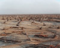
Soon the landscape became crowded with nodding oil wells – the Belridge Oil Fields of the Antelope Plain. Speeding over a rise I came into the Midway Valley, where I noticed several banks of steam rising dotting the bleak landscape. Usually, for me, this is a sign of unreconstructed hot springs – ones I can bathe in and, with a little work with a shovel, can tune to my liking. I stopped near one steaming vent to reconnoiter.
 It wasn’t a hot spring, however, but a set of bubbling, oozing, tar pits, rank with the smell of sulphur. Interesting to see, but not something you want to bathe in.
Aside: The people who want to develop the oil feilds in the Alaskan National Wildlife Refuge (ANWR) say that they can do so with minimal impact on the natural environment. I hope they can, because it's clear that the Antelope Plain has been permanently scared by oil extraction.
I pressed on, passing through the oil town of Maricopa and down into the green farmlands of the Cuyuma Valley that looks up to the snow-dusted, 6000-foot peaks of the on the Sierra Madre Mountains and the Los Padres National Forest, where I was bound. Driving into the mountains the landscape became dramatic and views back down into the spectacular. The road wound up to the Pine Mountain (about 5000 feet) and down the other side into the breathtaking Sespe and Wheeler Gorges.
The picture-perfect little wine-growing town of Ojai is literally nestled between the Santa Ynez and Sulphur mountain ranges. I stopped for a bit to stretch my legs and get a bite to eat.
At last I made my way home through Moorpark, Thousand Oaks and back into the Valley along 101.
What I loved about this journey was that within four hours I was able to experience a wide variety of landscape and history, simply by taking my time as well and a less-travelled road.
Coming home from a wild warehouse party in the badlands of San Francisco on Sunday morning (more on that later, when I get the pictures), I stopped at Harris Ranch to buy some fresh Harris Ranch beef to bring to some friends at in the south. I bought some pre-cooked BBQ ribs, a Bobby Darren CD and a map – I had forgotten to bring one on the way up.Looking at the map I noticed a thin red line running southward that vaguely paralleled the I-5, but to the west, called Highway 33. There was little on the map to indicate any points of interest, but I was curious and decided to take a chance. It turned out to be a chance well taken.
I took State Highway 198 East to toward Coalinga, a little town noted only for a famous kidnapping of an entire school bus full of children in the 1970s, when I was a boy. Where 198 met 33, I noticed a historical marker. I pulled over to investigate and was pleased – no, thrilled – to see that it marked the place where Joaquin Murietta, the notorious bandit of early California and the precursor of Zorro, was finally killed and beheaded. Actually the marker, California State Marker # 344 doesn’t mark the exact spot of the killing, but points rather to it – about 15 miles up a dirt road that winds around Black Mountain peak. Since I was not equipped for this route, I opted to continue south. Now that I know it’s there, I’ll one day visit the place where Murietta lost his head and his accomplice, three-fingered Jack, lost the rest of his handas well as his life.
I passed through the little towns of Coalinga and Avenal and on sped through the cattle country of the Kettleman Plain, with the rolling Kettleman hills to the east and the Reef Ridge to the west. It being the wet season in California everything was green and in bloom. The bright green of the grass was broken by the bright yellow of the mustard blossoms as well as by the purple of… well, I don’t know what the little flowers are called, nor does it matter much, but they were gorgeous in the morning light.
Eventually I came to a crossroads populated only by a little mon-and-pop gas station and corner market. Its sign read: “THE WORLD’S LARGEST PARKING LOT.” If any claim of grandiosity deserves scrutiny, well, that’s pretty much it. I went in and bought some soda and asked the man behind the counter: “So is this really the world’s largest parking lot?”
He said: “General Patton used to do maneuvers around here. His tanks were parked behind us. They stretched from here to the hills. One giant parking lot of tanks. That’s what Pattoned called it – ‘the world’s largest partking lot’.”
Looking out over that fertile grassland I tried to imagine it but could not. Moving further southward, however, I could see better the general’s plan. As I sped south, the countryside changed dramatically. Fresno County giving way to Kings County and Kings County to Kern. Grassland gave way to dry, desert alkali soil and tumbleweeds – Patton’s war planners must have thought it a good stand-in for parts of North Africa, where Patton finally took on and defeated Rommel. It must have been a magnificent sight t to see. But the fantasy was short lived.Soon the landscape became crowded with nodding oil wells – the Belridge Oil Fields of the Antelope Plain. Speeding over a rise I came into the Midway Valley, where I noticed several banks of steam rising dotting the bleak landscape. Usually, for me, this is a sign of unreconstructed hot springs – ones I can bathe in and, with a little work with a shovel, can tune to my liking. I stopped near one steaming vent to reconnoiter.
It wasn’t a hot spring, however, but a set of bubbling, oozing, tar pits, rank with the smell of sulphur. Interesting to see, but not something you want to bathe in.Aside: The people who want to develop the oil feilds in the Alaskan National Wildlife Refuge (ANWR) say that they can do so with minimal impact on the natural environment. I hope they can, because it's clear that the Antelope Plain has been permanently scared by oil extraction.
I pressed on, passing through the oil town of Maricopa and down into the green farmlands of the Cuyuma Valley that looks up to the snow-dusted, 6000-foot peaks of the on the Sierra Madre Mountains and the
Los Padres National Forest, where I was bound. Driving into the mountains the landscape became dramatic and views back down into the spectacular. The road wound up to the Pine Mountain (about 5000 feet) and down the other side into the breathtaking Sespe and Wheeler Gorges.The picture-perfect little wine-growing town of Ojai is literally nestled between the Santa Ynez and Sulphur mountain ranges. I stopped for a bit to stretch my legs and get a bite to eat.
Tip: If you live in the L.A. area, don’t bother with Santa Barbara’s wine country; go to Ojai instead. It’s closer, less crowded, less formal and feels like the Napa Valley in the funky 1970s.
At last I made my way home through Moorpark, Thousand Oaks and back into the Valley along 101.
What I loved about this journey was that within four hours I was able to experience a wide variety of landscape and history, simply by taking my time as well and a less-travelled road.
posted by M2 at 7:40 AM
![]()
![]()


4 Comments:
Great example of Geotourism!
>> What I loved about this journey was that within four hours I was able to experience a wide variety of landscape and history, simply by taking my time as well and a less-travelled road.<<
Embrace KM=Knowledge Management with ALL-WinWin SE=Social Engineering ***
Great example of Geotourism!
>> What I loved about this journey was that within four hours I was able to experience a wide variety of landscape and history, simply by taking my time as well and a less-travelled road.<<
Embrace KM=Knowledge Management with ALL-WinWin SE=Social Engineering ***
The School Bus Kidnapping was from Chowchilla, Ca., some 80 miles from Coalinga, and is on Highway 99, vs. 33 & 198. The bus was buried near Pleasanton, Ca.
Murietta was no Zorro, and his gang of thugs were rounded up in Cantua Creek which is 30 plus miles north of Coalinga.
Other than these two errors, the area travelled is interesting and has it's own character during each season of the year.
Post a Comment
<< Home